One of the main reasons that I visited Mapungubwe NP was to visit the heritage site here. It is an African Iron age site and part of the complex that includes Great Zimbabwe but pre-dating it. The original settlement is now known as K2 and was in an adjacent valley to the south of Mapungubwe hill, occupied between 1030 to 1220 CE. At around 1220 CE, Mapungubwe hill was occupied, with the royal household on top of the defensible hill and the commoners in the valleys below, which was a change to the traditional ‘central cattle model’ utilised in African settlements up to this period. At its height, it was believed that Mapungubwe had about 5000 inhabitants. Mapungubwe was abandoned around 1300 CE, probably due to a severe drought and it is believed that the people moved north and founded Great Zimbabwe.
 |
| Mapungubwe Hill. The royal household was on top with only a single, easily defended pathway up. The 'commoners' lived on the low ground around the base of the hill. |
 |
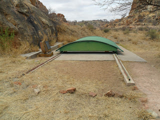
| The movable cover on one of the archaeological pits. |
 |
| The same pit, showing the fold up safety railings. |
 |
| The railings folded up. |
 |
| The site of K2 on an adjacent hill. |
 |
| K2 again. |
 |
| The sentry post on the single access to the top of Mapungubwe Hill. |
 |
| One of the mortars for pulping up foodstuffs. |
 |
| One of the hut footings for a wall. |
 |
| One of the strategy 'games' played by the men, moving pieces into the holes to take opponents pieces. |
 |
| Another game played by tossing and catching stones, while knocking the surrounding stones into the central hole, then snatching them all out. |
 |
| A water cistern carved out of the rock. |
 |
| A grain storage pit carved out of the rock. |
No comments:
Post a Comment